Showing posts with label himachal pradesh. Show all posts
Showing posts with label himachal pradesh. Show all posts
Friday, December 2, 2011


==%22undefined%22){networkedblogs%20=%20{};networkedblogs.blogId=1121701;networkedblogs.shortName=%22eye2clicks-by-diink%22;}%20%3C/script%3E%3Cscript%20src=%22http://nwidget.networkedblogs.com/getnetworkwidget?bid=1121701%22%20type=%22text/javascript%22%3E%3C/script%3E)
Sunday, May 1, 2011
Khajjiar (A photowalk with Diink)

Khajjiar is a hill station in Chamba district, Himachal Pradesh, India, located at an approximate of 24 km from Dalhousie
Khajjiar sits on a small plateau with a small stream-fed lake in the middle that has been covered over with weeds. The hill station is surrounded by green meadows and dense forests. It is about 6500 ft. (1981m) above sea level in the foothills of the Dhauladhar ranges of the Western Himalayas and snowy peaks can be seen in the distance.
Khajjiar is often called the Mini Switzerland of Himachal Pradesh and was officially baptized thus by the Swiss Ambassador on July 7, 1992. It has a rare combination of three ecosystems: lake, pasture and forest, all in one place. Khajjiar can be reached from Dalhousie, the nearest major town and hill station, by bus in an hour or so. There are two buses in the morning that leave at around 9:30. The last bus that returns from Khajjiar to Dalhousie is at 3:30 PM.


 Khajjiar Lake is situated in district Chamba. It is about 1,900 m above sea level.
It is considered as a sacred place to Khajjinags (after whom this place is named after) Khajjiar has thick forest cover of the Kalatope sanctuary.
Khajjiar Lake is situated in district Chamba. It is about 1,900 m above sea level.
It is considered as a sacred place to Khajjinags (after whom this place is named after) Khajjiar has thick forest cover of the Kalatope sanctuary.


Khajjiar sits on a small plateau with a small stream-fed lake in the middle that has been covered over with weeds. The hill station is surrounded by green meadows and dense forests. It is about 6500 ft. (1981m) above sea level in the foothills of the Dhauladhar ranges of the Western Himalayas and snowy peaks can be seen in the distance.
Khajjiar is often called the Mini Switzerland of Himachal Pradesh and was officially baptized thus by the Swiss Ambassador on July 7, 1992. It has a rare combination of three ecosystems: lake, pasture and forest, all in one place. Khajjiar can be reached from Dalhousie, the nearest major town and hill station, by bus in an hour or so. There are two buses in the morning that leave at around 9:30. The last bus that returns from Khajjiar to Dalhousie is at 3:30 PM.


 Khajjiar Lake is situated in district Chamba. It is about 1,900 m above sea level.

Saturday, April 30, 2011
Kashmir (A photowalk with Diink)

Kashmir (The Paradise on Earth) (Balti, Gojri, Poonchi/Chibhali, Shina: کشمیر; Dogri: कश्मीर; Kashmiri: कॅशीर, کٔشِیر; Ladakhi: ཀཤམིར; Uyghur: كەشمىر) is the northwestern region of the Indian subcontinent. Until the mid-19th century, the term Kashmir geographically denoted only the valley between the Great Himalayas and the Pir Panjal mountain range. Today Kashmir denotes a larger area that includes the Indian-administered state of Jammu and Kashmir (the Kashmir valley, Jammu and Ladakh), the Pakistani-administered Gilgit-Baltistan and the Azad Kashmir provinces, and the Chinese-administered regions of Aksai Chin and Trans-Karakoram Tract.
In the first half of the first millennium, the Kashmir region became an important center of Hinduism and later of Buddhism; later still, in the ninth century, Kashmir Shaivism arose.In 1349, Shah Mir became the first Muslim ruler of Kashmir and inaugurated the Salatin-i-Kashmir or Swati dynasty.For the next five centuries, Muslim monarchs ruled Kashmir, including the Mughals, who ruled from 1526 until 1751, then the Afghan Durrani Empire that ruled from 1747 until 1820.That year, the Sikhs under Ranjit Singh, annexed Kashmir.In 1846, upon the purchase of the region from the British under the Treaty of Amritsar, the Dogras—under Gulab Singh—became the new rulers.
 Dal Lake is a lake in Srinagar, the summer capital of the northernmost Indian state of Jammu and Kashmir. The urban lake, which is the second largest in the state, is integral to tourism and recreation in Kashmir and is nicknamed the "Jewel in the crown of Kashmir"[or "Srinagar's Jewel".The lake is also an important source for commercial operations in fishing and water plant harvesting.
The shore line of the lake, about 15.5 kilometres (9.6 mi), is encompassed by a boulevard lined with Mughal era gardens, parks, houseboats and hotels. Scenic views of the lake can be witnessed from the shore line Mughal gardens, such as Shalimar Bagh and Nishat Bagh built during the reign of Mughal Emperor Jahangir) and from houseboats cruising along the lake in the colourful shikaras.During the winter season, the temperature sometimes reaches −11 °C (12.2 °F), freezing the lake.
The lake covers an area of 18 square kilometres (6.9 sq mi) and is part of a natural wetland which covers 21.1 square kilometres (8.1 sq mi), including its floating gardens. The floating gardens, known as "Rad" in Kashmiri, blossom with lotus flowers during July and August. The wetland is divided by causeways into four basins; Gagribal, Lokut Dal, Bod Dal and Nagin (although Nagin is also considered as an independent lake). Lokut-dal and Bod-dal each have an island in the centre, known as Rup Lank (or Char Chinari) and Sona Lank respectively.
At present, the Dal Lake and its Mughal gardens, Shalimar Bagh and the Nishat Bagh on its periphery are undergoing intensive restoration measures to fully address the serious eutrophication problems experienced by the lake. Massive investments of around US $275 million (Rs 1100 crores) is being made by the Government of India to restore the lake to its original splendour.
 The Hazratbal Shrine (Kashmiri: حضرت بل, हज़रतबल; Urdu: حضرت بل, literally: Majestic Place), is a Muslim shrine in Srinagar, India. It contains a relic believed by many Muslims of Kashmir to be a hair of the Islamic prophet Muhammad. The name of the shrine comes from the Arabic word Hazrat, meaning holy or majestic, and the Kashmiri word bal, (bal is a corrupted form of Sanskrit Vala which means an enclosure) meaning place.
The shrine is situated on the left bank of the Dal Lake, Srinagar and is considered to be Kashmir's holiest Muslim shrine.The Moi-e-Muqqadas (the sacred hair) of Mohammed is believed to be preserved here. The shrine is known by many names including Hazratbal, Assar-e-Sharief, Madinat-us-Sani, or simply Dargah Sharif.

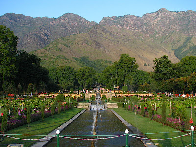
Nishat Bagh (Urdu: نشات باغ, Hindi: निशात बाग़), is a Mughal garden built on the eastern side of the Dal Lake, close to the Srinagar city in the state of Jammu and Kashmir. It is the second largest Mughal garden in the Kashmir Valley. The largest in size is the Shalimar Bagh, which is also located on the bank of the Dal Lake. ‘Nishat Bagh’is a Hindustani word, which means "Garden of Joy," "Garden of Gladness" and "Garden of Delight."


The shore line of the lake, about 15.5 kilometres (9.6 mi), is encompassed by a boulevard lined with Mughal era gardens, parks, houseboats and hotels. Scenic views of the lake can be witnessed from the shore line Mughal gardens, such as Shalimar Bagh and Nishat Bagh built during the reign of Mughal Emperor Jahangir) and from houseboats cruising along the lake in the colourful shikaras.During the winter season, the temperature sometimes reaches −11 °C (12.2 °F), freezing the lake.
The lake covers an area of 18 square kilometres (6.9 sq mi) and is part of a natural wetland which covers 21.1 square kilometres (8.1 sq mi), including its floating gardens. The floating gardens, known as "Rad" in Kashmiri, blossom with lotus flowers during July and August. The wetland is divided by causeways into four basins; Gagribal, Lokut Dal, Bod Dal and Nagin (although Nagin is also considered as an independent lake). Lokut-dal and Bod-dal each have an island in the centre, known as Rup Lank (or Char Chinari) and Sona Lank respectively.
At present, the Dal Lake and its Mughal gardens, Shalimar Bagh and the Nishat Bagh on its periphery are undergoing intensive restoration measures to fully address the serious eutrophication problems experienced by the lake. Massive investments of around US $275 million (Rs 1100 crores) is being made by the Government of India to restore the lake to its original splendour.

The shrine is situated on the left bank of the Dal Lake, Srinagar and is considered to be Kashmir's holiest Muslim shrine.The Moi-e-Muqqadas (the sacred hair) of Mohammed is believed to be preserved here. The shrine is known by many names including Hazratbal, Assar-e-Sharief, Madinat-us-Sani, or simply Dargah Sharif.

Nishat Bagh (Urdu: نشات باغ, Hindi: निशात बाग़), is a Mughal garden built on the eastern side of the Dal Lake, close to the Srinagar city in the state of Jammu and Kashmir. It is the second largest Mughal garden in the Kashmir Valley. The largest in size is the Shalimar Bagh, which is also located on the bank of the Dal Lake. ‘Nishat Bagh’is a Hindustani word, which means "Garden of Joy," "Garden of Gladness" and "Garden of Delight."


When ever I visit kashmir , I prefer staying in a houseboat in Dal lake.The Dal Lake which has the length of 8 Km long and a width of 4 Km, spreads over a total of 26 Sq. Km. The fascinating Dal Lake is divided into two smaller ones the Lokut (small) and Bod (big) Dal. The south western part of the lake has a maximum depth of approximately 12 M. the Dal Lake gets some of its water from spring but is also supplemented by water from the mountain lake, Mar Sar. In the western part of the Lake one can glimpse a few islands, some bigger, some smaller. Its shores are very fertile and surrounded by willows. Potato, tomato, pumpkin, cucumber, radish and lots of other vegetables are grown here cultivation of the floating gardens which also lie in this part of the lake is another interesting feature. These gardens consist of reed rafts of different lengths and a width of approximately one and a half by three meters and are covered by 1020 CM thick layer of earth and mud. Vegetables and melons are grown on these artificial floating islands.
Saturday, January 15, 2011
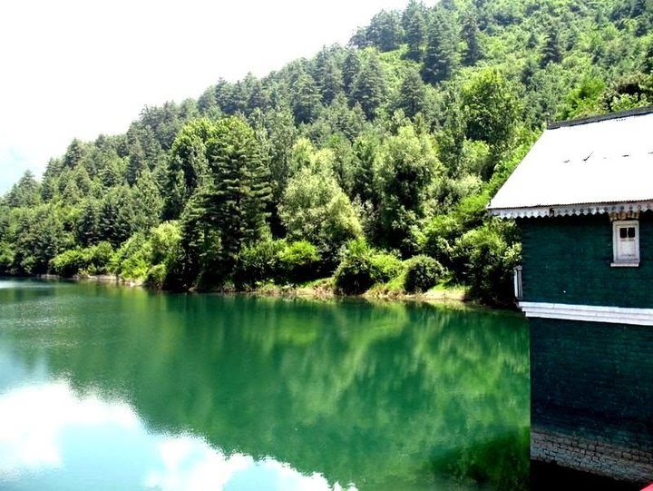
Bhaderwah- UnTouched Beauty (SoFar)~(A photowalk with Diink)


Bhaderwah is a small valley-town in Doda (India /Jammu and Kashmir/ Doda). Bhaderwah valley is predominantly a mountainous torrid town situated 80 km from Batote. The festive mood in the district begins with the melting of snow in April and the sprouting of greenery all round. Kailash Yatra is
another famous pilgrimage of the area which is considered an important Hindu pilgrimage. Bhaderwah offers to the tourist a variety of beautiful landscape, colourful local fairs, important festival mood and unique mosaic culture, extremely and pleasant summer temperature ranges from 18 degrees to 32 degrees. Popularly called Chhota-Kashmir, has bewitching natural beauty which enthrills any visitor.
© Diink...All Rights Reserved.®
The main hub to reach Bhaderwah is Jammu. It is approximately 200 Kms form Jammu to Bhaderwah by road. The road can be divided in four main spots as:
Jammu - Udhampur : 65 aprox (by road), - NH-1A - {50 Kms (by Train)}
Udhampur - Batote : 55 Kms - NH-1A
Batote - Pul Doda : 50 Kms - NH-1B
Pul Doda - Bhaderwah : 30 Kms
*********
© Diink...All Rights Reserved.®
ALL RIGHTS RESERVED WORLDWIDE. NOT TO BE REPRODUCED WITHOUT WRITTEN AUTHORIZATION.
Subscribe to:
Posts (Atom)